Human Impact and Colluvial Sediment Storages in Europe since the Neolithic
- Research Programme
- State of the art at the beginning of the project
- Results
- Publications
- Project Data
Research Programme
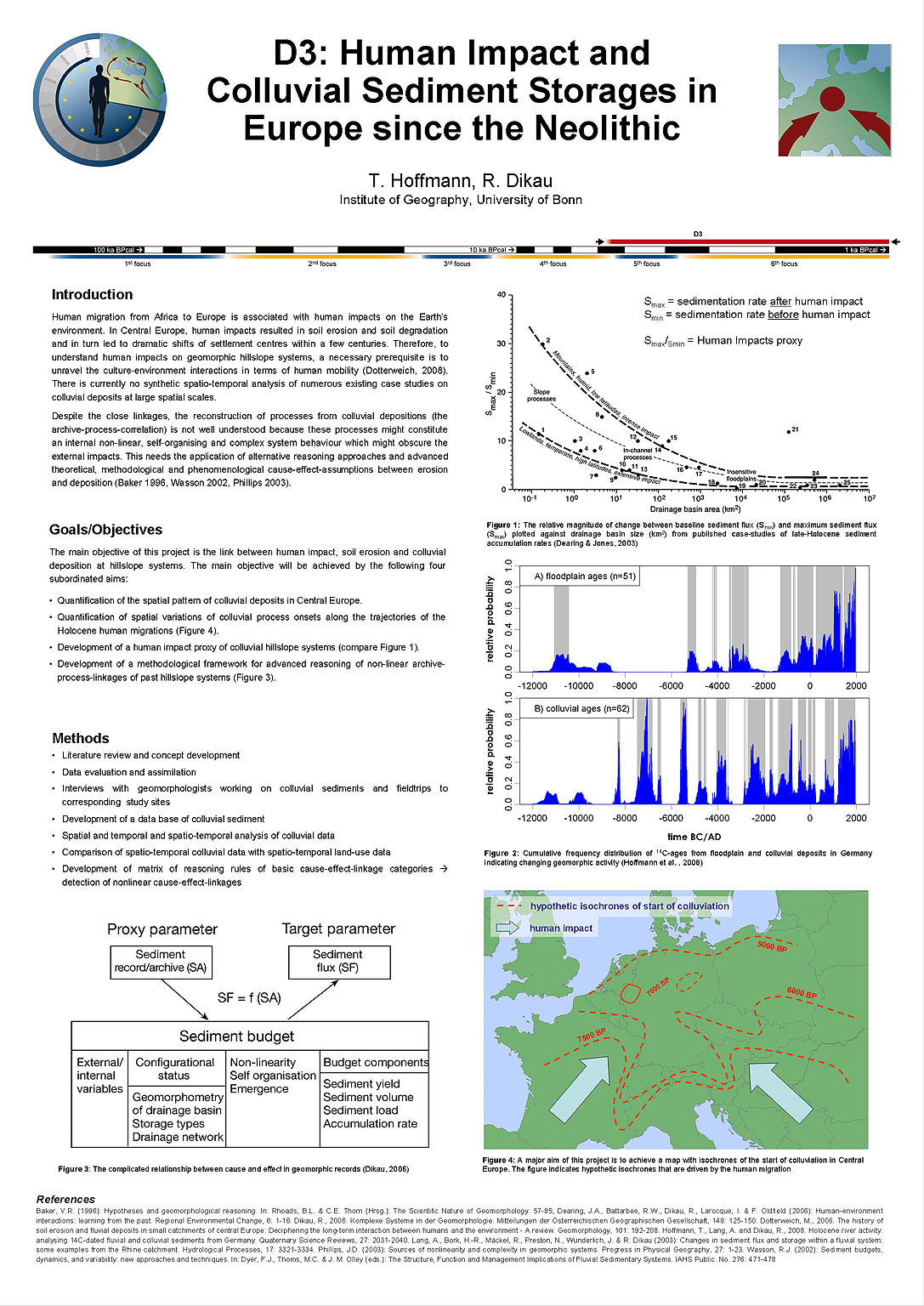
Human migration from Africa to Europe, particularly during the Holocene, is associated with human impacts on the Earth’s environment. To understand cultureenvironment interactions in terms of human mobility necessitates understanding the human impact on geomorphic hillslope systems. The main objective of this project is the link between human impact, soil erosion and colluvial deposition at hillslope systems. We will develop a human impact proxy of colluvial systems, which includes the spatial and temporal differences of system response magnitudes at the hillslope scale.
In Central Europe, human impacts resulted in soil erosion and soil degradation and in turn led to dramatic shifts of settlement centres within a few centuries. Therefore, to understand human impacts on geomorphic hillslope systems is a necessary prerequisite is to unravel the culture-environment interactions in terms of human mobility.
The main objective of this project is the link between human impact, soil erosion and colluvial deposition in hillslope systems. It will be achieved by completing the following four subordinated aims:
- Quantification of the spatial pattern of colluvial deposits in Central Europe.
- Quantification of spatial variations of colluvial process onsets along the trajectories of the Holocene human migrations.
- Development of a human impact proxy of colluvial hillslope systems.
- Development of a methodological framework for advanced reasoning of nonlinear archive-process-linkages of past hillslope systems.
The quantification of recent spatial patterns of colluvial deposits requires a two-scale approach including upscaling und downscaling modelling approaches. It is planned to combine local data, which will be taken from published case studies, with regional data (e.g. digital elevation model, digital soil map and digital geological map) that cover the entire target scale (Central Europe). The modelling approach of the spatial variations of the onset of colluvial processes along the trajectories of the Holocene human migrations will be accomplished by the generation of regional isoline maps. These will then be combined with maps of the spatial and temporal distribution of prehistoric settlements to develop a human impact proxy of colluvial hillslope systems. The analysis of the colluvial record will be complemented by the development of a methodological framework, which will analyse the complex and non-linear forcing-response-relationship inherent in palaeoenvironmental studies.
The major contribution of this project to the CRC therefore is to study the human impact on colluvial systems, which in turn contribute to the internal migration in Central Europe. Furthermore, we will develop a methodological framework to analyse geomorphic archives in terms of complex and non-linear forcing-response-relationship, which is of major importance for the geomorphological interpretations
State of the art at the beginning of the project
Soil erosion resulted in deposition of colluvial sediment at the foot of hillslopes. Due to the short travel distance of sediment on these slopes, it is assumed that there is a direct link between soil erosion processes and the colluvial sedimentation resulting in reliable records of the external impacts preserved in the stratigraphic records of the colluvial material. However, despite these close linkages the reconstruction of processes from colluvial depositions (the archive-processcorrelation) is not well understood because these processes might constitute an internal non-linear, self-organising and complex system behaviour which might obscure the external impacts (Dearing & Jones 2003, Phillips 2003).
Despite numerous small-scale geomorphic case studies on colluvial deposits in Central Europe (CE), a large scale synoptic analysis of these sediments is missing. Consequently, little is known about regional differences in the timing of the onset of the colluviation processes and the magnitude of responses of hillslope systems to human impacts. Concerning the impact of global environmental change on geomorphic systems and in particular on sediment fluxes, it is important to increase our understanding of spatial differences of the timing and magnitude of colluvial depositions. Therefore, it is necessary
- to identify spatial differences in timing of the onsets of colluvial deposition,
- to evaluate spatially and temporally variable magnitudes of hillslope responses to human impacts,
- to analyse the differences in timing (frequency) and magnitude, aiming to explain the principal ways in which human impact influences terrestrial sediment fluxes,
- to understand the coupling and temporal dynamics of the soil erosion and deposition process caused by non-linear forcing-response relations.
Reconstructing the history and the processes of colluvial deposition, in turn, will help to identify the causes of human internal migration within Europe.
The cyclic behaviour of environmental change at different temporal and spatial scales necessitates a long-term perspective on human-environment interactions (Dearing et al. 2006). Holocene sediment budgets are a promising approach to quantify the impacts of land use and climate change on geomorphic systems and to consider the scale-dependent cyclic behaviour of environmental changes. At the hillslope scale, numerous detailed and temporally resolved investigations of colluvial sediment storages exist (e. g. Bork et al. 1998, Kalis et al. 2003, Lang et al. 2003a, b, Litt 2003, Preston & Dikau 2004, Zolitschka et al. 2003). The detailed studies on colluvial sediments in CE provide a sound basis for a large-scale synoptic analysis, which is currently missing. In the case of the Rhine River system, Hoffmann et al. (2007) used data at different spatial scales in combination with an up-scaling approach to estimate the alluvial sediment and carbon storage in the Rhine catchment. Dearing & Jones (2003) developed a human impact proxy based on a global dataset from lacustrine and marine environments. Their results emphasize the major importance of the spatial scales of sediment fluxes.
Based on the state of the art at the, the main objectives of the project are to understand the link between human impact, soil erosion and colluvial deposition on hillslopes in CE during the period of agriculture. The main objective was studied based on the subordinated aims, which were described in the project proposal:
Aim 1: Quantification of the spatial patterns of colluvial deposits in CE.
Aim 2: Quantification of spatial variations of colluvial process onsets along the trajectories of the Holocene human migrations.
Aim 3: Development of a human impact proxy of colluvial hillslope systems.
Aim 4: Development of a methodological framework for advanced reasoning of nonlinear archiveprocess-linkages of past hillslope systems.
This project report represents the work performed under the objectives 1 to 3. Results of aim 3 are presented together with aim 3. Aim 4 was associated with a second PhD student that was not financed by the DFG. Therefore progress regarding aim 4 was limited. To discuss issues related to aim 4, the PIs of the D3 Project initiated two working groups within the CRC were initiated to discuss general theoretical and methodological issues of the CRC. Outcomes are presented in Widlok et al. (2012).
Results
To establish an empirical basis for the aim 1 – 3, a database of colluvial deposits for CE has been compiled including data from 56 case studies and 71 catchments. Overall, 307 sediment ages (OSL and 14C), and the total storage volumes of 40 catchments were included in the database.
Aim 1 + 3
Two different approaches were applied to quantify the spatial patterns of colluvial deposits in CE:
- analysis of the scaling behaviour of Holocene colluvial sediment storage
- modelling of soil erosion and colluvial deposition for different spatial scales and different cultural periods since the Neolithic.
The scaling analysis (approach a) included published empirical sediment storage data from 40 catchments in CE. Based on these storage data, we analysed the relationship between catchment area A [km²] and colluvial sediment storage mass S [t] with S = a (A/Aref)b (Eq. 1), where b is the scaling exponent and a [t] the storage related to an arbitrarily chosen reference area Aref (here Aref = 1000 km²). Regression coefficients a and b were determined using linear regression (LR) of logtransformed data. Errors of the regression coefficients are given by the standard deviation of 2000 bootstrap estimates. Using this method we calculated Sloess = (4.2±0.8)*105 A1.06±0.06 for loess catchments and Snon-loess = (1.7±0.4)*105 A1.09±0.09 for non-loess catchments. After estimation of b for colluvial deposits, a can be calculated for each study site using a = S (A/Aref)-b (Eq. 2), which represents a scale independent storage coefficient which is comparable between each budgets sites. We, therefore, assume that a is related to the human-induced soil erosion in each catchment.
To predict colluvial sediment storage in the Rhine basin, we use Eq. 1 to calculate hillslope sediment storage for the non-alpine part of the Rhine basin (125.000 km2). We thus assume that there is no scale break beyond the largest studied hillslope budget in the Rhine basin. This assumption seems to be reliable, since there are no obvious scales breaks in the empirical data and since we limit our study upstream to the Rhine delta apex, which is associated with a change in geomorphic conditions.
Calculated colluvial sediment storage in the non-alpine part of the Rhine catchment results in a total hillslope storage of (66 ± 6) × 109 t. This is in the same order of magnitude as sediment stored in the floodplains (59 ± 14) × 109 t according to Hoffmann et al. (2007). Of special interest in terms of the spatial variable human impact are differences of the a-coefficient between loess and non-loess catchments. The impacts of continuous farming since the Neolithic and the associated higher population density in loess areas are mirrored by a larger aloess = (620 ± 260) × 106 t compare to anon-loess = (340 ± 260) × 106 t, indicating twice as much hillslope storage in loess areas. Scaling exponents in both areas are statistically indistinguishable with minor increases of sediment storage per basin area (b = 1.04 ± 0.4 and 1.09 ± 0.9, respectively). These results are consistent with more extensive and sustained soil erosion and deposition in fertile loess areas, due to longer human occupancy, and more massive, and highly erodible soils. These results seems to confirm the choice of a as a human-impact proxy. However, the site specific hillslope storage a varies spatially and shows no consistent pattern in comparison to the assumed onset of agricultural activity in Central Europe (compare also aim 2). This indicates that in terms of total deposition, the Neolithic soil erosion and sediment deposition is of limited significance.
The scaling analysis represents a spatially lumped model. To consider the spatial or temporal variability of the underlying soil erosion and sedimentation processes, we applied a soil erosion and sediment deposition model (approach b) to account for the spatio-temporal patterns of colluvial deposition. We used the spatially distributed soil erosion and deposition model WATEM/SEDEM (van Oost et al. 2000, van Rompaey et al. 2001) to model soil erosion and colluvial deposition for different land use scenarios. Input parameters of the WATEM/SEDEM model include geomorphometric parameters (LS-factor) derived from digital elevation models (10 m grid size), soil properties (K-factor) derived from soil maps (BK 25 and BK 50), scenarios for precipitation (Rfactor) based on dendrochronological data from Büntgen et al. (2011), and information on crops and tillage (C-factor) from archaeological studies and historical geography. We validated the model based on empirical Holocene sediment budgets and comprehensive datasets on (pre)historical land use, which were available for the Altdorfer Delle (Kölner Bucht), the Rockenberg catchment (Wetterau), the Eichenbach and the Lauterbach catchment (Pleiser Hügelland). Sensitivity analysis was carried out for each input variable to evaluate the uncertainty of the model results. To model past soil erosion and deposition we developed landuse scenarios for (pre)historic periods by a multiple objective land use allocation (based on Peeters, 2007 and Notebaert et al. 2011). Historical maps, archaeological data on settlement locations, population densities and necessary arable land per household as well as data on land use systems, woodland management from palaeobotany and historical geography (e.g. Dikau & Lippert, unpubl.) were included. The application of the WATEM/SEDEM model to the area covered by the Geschichtlicher Atlas der Rheinlande (32000 km2), which presents large-scale historical land use data, is currently in progress.
Modelled scenarios of soil erosion for the Altdorfer Delle using WATEM/SEDEM correspond well with empirical soil erosion rates estimated by Schulz (2007). In general, soil erosion and deposition during the successive cultural epochs increased steadily, due to an ever increasing population density during the climax of each epoch. The underestimation of current soil erosion rates could be addressed to the limited representation of tillage erosion that is of major importance during the last decades (van Oost et al. 2005). The model generally overestimates colluvial deposition in all periods except for the last 200 years. This could be caused by an underestimation of the sediment transport capacity within the model or to remobilization and export of colluvial sediments after deposition. If the later is true, colluvial deposition in the empirical budget is underestimate in early land use periods. In general, the model results suggest that WATEM/SEDEM is suitable to model past soil erosion and deposition. Especially in cases were land use reconstructions are underpinned by archaeological evidences (as in the case of the Altdorfer Delle), WATEM/SEDEM reproduces consistent results. These positive outcomes motivate the application of WATEM/SEDEM at larger scales, which are less well constrained in terms of the land use history, compared to the small scale test sites. The intended modelling study could be an adequate approach to understand the different impacts of human agricultural activity in loess-covered lowlands of the Niederheinische Bucht compared to hilly uplands of the Rhenish slate massif.
Aim 2
The spatial variation of the onset of colluvial sedimentation along the trajectories of the Holocene human migrations is quantified by 83 published 14C or OSL ages of the lowermost dated colluvial sediments in CE. Relative cumulative frequency analyses of the "onset-ages" were performed to define regional differences of the start of colluvial deposition. At 27 sites colluvial deposition started in the Neolithic, while at 11 locations the colluvial base was even older than 7500 years. At the remaining 45 sampling points, colluvial deposition started during the Bronze Age or later.
Relative cumulative frequency distributions represent differences between loess dominated areas and upland regions. A larger number of ages between 7500 BP and 6000 BP in loess regions represent an earlier human impact compared to first evidences of colluviation in upland regions around 6100 BP (if ages older than 7500 BP are excluded). The ages in the upland regions strongly increase between 5500 BP and 3500 BP, while the loess regions show a nearly linear increase between 7500 and today. This age distribution mirrors the general assumption that Neolithic settlers preferred loess soils. However, the results are biased by the different sampling sizes of the dataset for the loess and upland regions.
Relative cumulative frequency distributions of basal ages in different regions of CE indicate the earliest process onset in Southwest Germany, including the Upper Rhine Graben, the Kraichgau and the Rhine-Main-region, while the oldest ages, especially those older than 7500 BP, occurred in the Taunus Mountains, the Rhine-Main region and the Kraichgau. Also in Northern Germany (Albersdorf, Reiß et al. 2008) and Southeast Germany (Frauenberg, Lang et al. 2003a, b) colluvial deposits from the Mesolithic have been found. These pre-Neolithic colluvial deposits are assumed to be associated with insufficient bleaching of the dated material (OSL, Lang et al. 2003) or mixedradiocarbon ages due to samples containing older and younger organic material (radiocarbon dating, Semmel 1995). Other studies consider the possibility of pre-Neolithic human impacts (Reiß et al. 2008) or relate these ages to natural processes such as slope wash processes on oversaturated soils during thawing under a sparse vegetation cover after the Younger Dryas (Stolz and Grunert 2006).
Overall, the process onset started earlier in the Southwest and Southeast than in the Northwest of Germany, which corresponds to the assumed spread of the Neolithic culture from the Southeast and Southwest to the North. However, the strong increase of the ages between 6000 and 4000 BP in the North and Northeast indicate an earlier neolithisation in this region than in Southeast Germany and the Lower Rhine area, which contrasts our current knowledge of the spread of Neolithic farming.
The discrepancy between the spread of the Neolithic and the scarcity of associated colluvial deposits can be associated with:
- the absence of Neolithic farming at the sampling site,
- thelimited impact of Neolithic farming and therefore limited soil erosion and deposition,
- the remobilization and export of Neolithic colluvial deposits in successive landuse periods, and
- thepedogenetic modification of colluvial deposits that hamper their identification in recent times (Bork et al. 1998)
- preferred storage in small pits and hollows that are not detected in augering and borehole transects (Gerlach et al. 2012) and
- issues associated with OSL-dating, that captures the last sediment redistribution and not the initial sedimentation time.
To test the hypothesis that the lack between wide spread Neolithic land use and limited colluvial deposits is caused by a limited preservation potential of Neolithic deposits, we modeled soil erosion and colluvial deposition using WATEM/SEDEM for the Linear Pottery period in the Altdorfer Delle. The Aldenhovener Platte is assumed to be a settlement center during the Linear Pottery with a high population density (1household/km²) (Zimmermann et al. 2009) compared to other regions during this time period (0.074 households/km² in the whole Rhineland Region). The Altdorfer Delle is assumed to be settled continuously during the Linear Pottery over 250 years with numbers of housholds ranging between 3 and 11 houses. Nevertheless, no colluvial deposits were identified for the Neolithic period by Schulz (2007). Based on reconstructed land-use scenarios (compare aim 1) soil erosion and deposition were modeled by WATEM/SEDEM for the Linear Pottery and compared to the empirical sediment budget.
Predicted soil erosion and deposition rates based on reconstructed land use scenarios range between 0.08 and 0.69 t ha-1a-1, and between 0.07 und 0.68 t ha-1a-1, respectively. Overall, 10,475 t have been eroded and 9988 t have been deposited in the Altdorfer Delle during the Linear Pottery (250 years), which correspond to a 5.7 mm erosion in 250 years and 5.4 mm deposition in the same period. The area of deposition comprises 6.5 ha according to Schulz (2007) and 2.9 ha according to the WATEM/SEDEM, which corresponds to 10.2 or 23 cm of colluvial deposition along the thalweg. We argue that, in the case of total preservation, the calculated deposition of 10-23cm of Neolithic deposits should be clearly identifiably in the cross-section excavated by Schulz (2007) (see his Figure 11, p. 112). Due to the good correspondence of the modeled and empirical erosion rates, we argue that the preservation potential of Neolithic colluvial deposits is rather low and that soil erosion rates derived from presently preserved colluvial deposits underestimate soil erosion rates during the Neolithic. However, modeled Neolithic erosion rates are probably too low to cause
a substantial degradation of the soils. We therefore argue, that the end of Linear Pottery settlement in this catchment was not related to human-induced soil erosion and degraded soil resources. This assumption is in good correspondence with project D2, which indicates that there was no significant P depletion and no severe trace element depletion in Neolithic soils. Soil degradation and nutrient depletion are thus unlikely to play a major role for human mobility during the early history of human agricultural activity.
The results indicate that the assumed spread of the Neolithic way of life in Central Europe is not mirrored in the colluvial deposits at large scales (e.g. Central Europe). Only in loess regions, colluvial deposits (age of the lower most layer and storage mass, compare aim 1) reflect the earlier onset of colluviation compared to uplands. Our modeling results confirm the hypotheses that the preservation potential of Neolithic culluvial deposits is low and/or that current methods are not suitable to detect them. Neolithic human impact was high enough – at least in "densely" settled regions like the Aldenhovener Platte, to cause measurable soil erosion and colluvial deposition, but systemic and methodological causes like remobilization, pedogenetic modification or dating issues hamper the today´s identification.
| 1st Phase - Research Programme |
 |
| view Poster |

