Several concentrations of Late Pleistocene stone artefacts were documented during archaeological surveys in 2014 in the vicinity of Sodmein Cave. These open-air sites were preferentially registered on older surface remnants (terraces) – covered mainly with a dark desert pavement – south of the cave entrance. Two of these terraces were topographically documented using a DGPS. During the course of this, it became increasingly clear that these terraces probably represent parts of the former Pleistocene surface of the area. The recovered artefacts exhibited both classical Levallois as well as Nubian and Taramsan technologies and therefore seem to indicate direct technological affinities with both the Egyptian Nile Valley and the Eastern Desert.
Through an interdisciplinary geographical and archaeological approach we attempted to
- reconstruct the former landscape of the Sodmein region,
- put the different terrace remnants in a chronological order, and
- correlate these results with the archaeological sequence of Sodmein Cave and the later archaeological sites of the Nile Valley.
To these ends, an archaeological survey was conducted on the terraces to document the different artefact concentrations and archaeological features. A portable device (SUERC Pulsed OSL) was used to measure luminescence signals in the field (Nicole Klasen, project F2). The OSL-/IRSL-signal ratio was used to correlate sections of different profiles with each other. To get a precise description of the terrace surface composition, single square metres were documented with hyperspectral pictures using a RIKOLA hyperspectral camera (in cooperation with project Z2). Such pictures reproduce the structure and colour of the characteristic desert pavement, which can later serve as a ground check for extrapolating and mapping further Late Pleistocene surfaces. For the reconstruction of the Pleistocene environment in the area of Sodmein Cave the recently collected geographical and archaeological data seems to be very promising.
| view arabic translation |
 Position of former terrace remnants (bordered with dashed lines) in Wadi Sodmein around 2.5 km south of the cave entrance. Left: terraces in the foreground and Sodmein Cave in the background (a car for scale in the red circle); right: the satellite image displays both terraces measured by DGPS. Photo: Dirk Hoffmeister (left) and Quickbird image (right) |
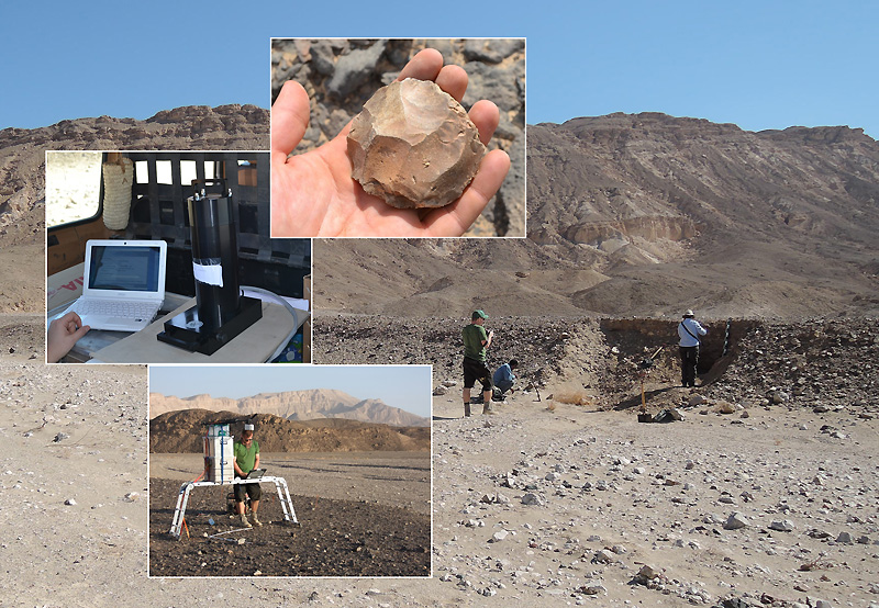 Interdisciplinary landscape approach in the field: Identifying and reconstructing probable Late Pleistocene surfaces in the area of Sodmein Cave. The background photo shows a typical terrace remnant in Wadi Sodmein. Small pictures from upper right to lower right: a Levallois core, the SUERC Pulsed OSL device and the ROKOLA hyperspectral camera for proper image acquisition. Photo: Karin Kindermann and Felix Henselowsky |


")

")

")


