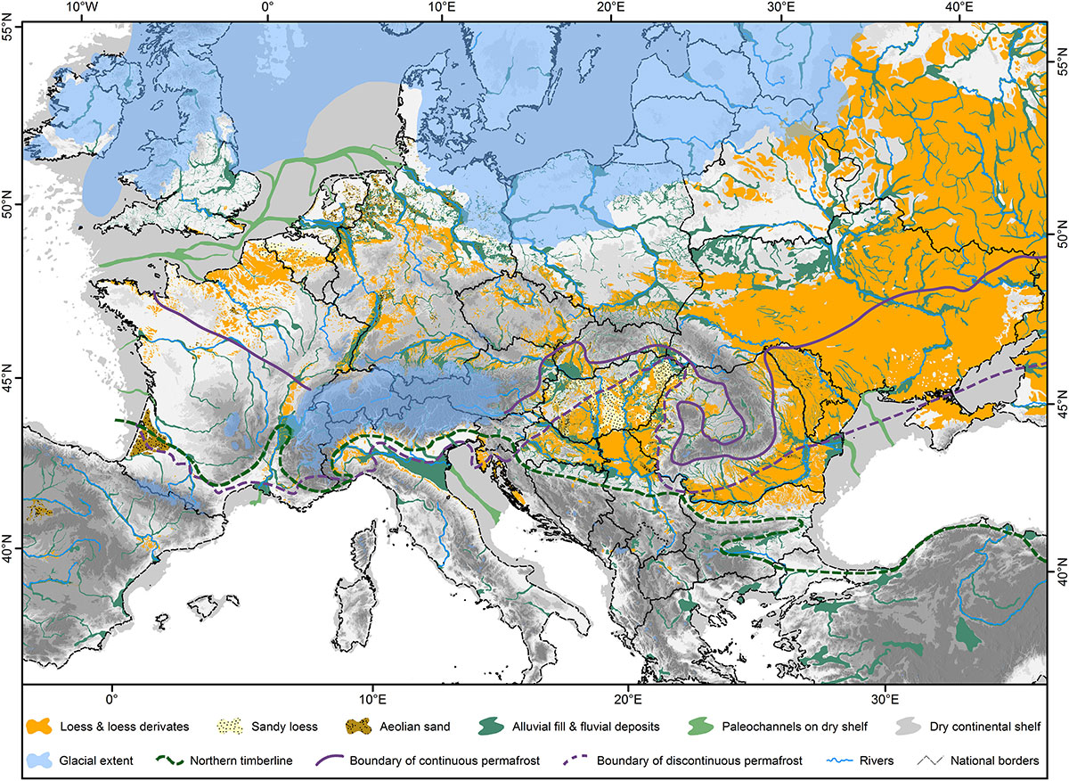
Maps are the most common way to visualise spatial data in an easily understandable way. Therefore, they are still used today as a powerful tool in, e.g., Quaternary sciences and archaeology. The knowledge of the distribution of Quaternary sediments such as loess is crucial to understand the formation of these deposits and their palaeoenvironmental implications. Throughout the last years, the team of the Chair of Physical Geography and Geoecology of the RWTH Aachen University together with a large team of international colleagues compiled geological, geomorphological, and pedological data to obtain a seamless map of loess distribution in Europe. After years of work, the map was finally finished last year. Besides the display of geospatial data, this map allows us to differentiate the European loess deposits according to their location, elevation, and potential source areas. The integration of stratigraphic and geomorphological evidence allowed us to delineate six domains and 17 subdomains of loess distribution in Europe, spanning from the Oceanic influenced loess areas of Southern England to the Mediterranean realm. The newly obtained data was the base for a new conceptual model of loess genesis in Europe, which can easily be transferred to other loess regions. The findings were recently published by CRC members and a large team of international colleagues from all over Europe in Earth-Science Reviews.
Lehmkuhl, F., Nett, J.J., Pötter, S., Schulte, P., Sprafke, T., Jary, Z., Antoine, P., Wacha, L., Wolf, D., Zerboni, A., Hošek, J., Marković, S.B., Obreht, I., Sümegi, P., Veres, D., Zeeden, C., Boemke, B., Schaubert, V., Viehweger, J. and Hambach, U. (in press):
Loess landscapes of Europe – Mapping, geomorphology, and zonal differentiation. Earth-Science Reviews.
https://doi.org/10.1016/j.earscirev.2020.103496
|
|


: First evidence for human occupation during the Pleistocene")


")


")

")
 in Alcalá de Henares, Madrid, 14–18 September, 2016")

 do talk: understanding past life through lithic artefacts")


