Non-invasive surface geophysical techniques are a useful tool to investigate the earth’s subsurface structure. In order to identify suitable locations for future drilling projects, the Qa Al’ Azraq mudflat in northern Jordan was investigated in March 2011 using three surface geophysical methods. Our investigations made use of the Transient Electromagnetic (TEM), the Direct Current Resistivity (DCR) and the Radiomagnetotelluric (RMT) methods.
A 5 km long subsurface resistivity model was derived from the geophysical data. The 1D TEM models are stitched together and presented as a 2D subsurface electrical resistivity section.
Previously, diffuse lithological boundaries were clearly detected. In particular, the precise depth to the basalt stream was identified along the section. From 0 to 3000 m along the section line the topsurface zone coincides with a clay layer intermixed with limestone, chert, gravel and plant roots. On top of the basalt stream, a quite thin soft clay layer can be observed.
The resistivity models derived by 1D/2D inversion of geophysical data are compared and calibrated with lithological data from boreholes available along the section.
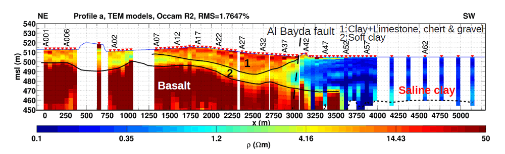 1D TEM models stitched together as a 2D section for the 5 km long profile. Illustration: Pritam Yogeshwar |


: First evidence for human occupation during the Pleistocene")


")


")

")
 in Alcalá de Henares, Madrid, 14–18 September, 2016")

 do talk: understanding past life through lithic artefacts")


