Late Quaternary High-Resolution Climate Archives in the Sahara

Into the Sahara Desert’s Deep Past. Expedition to the Remote Tibesti Mountains

It is hard to believe: We have sent a probe 500 million km to a comet to analyze rock samples, but no geologist has yet dug his spade into the crater of the highest mountain of the planet's major desert.

In mid-February 2015, a team of project A2 will leave N'Djaména for a c. 1000 km off-road journey to the Tibesti mountains of northern Chad, a lonely volcanic region covering more than 100,000 km2. The logistically challenging venture will include a two-week hike with 10 camels through the rough volcanic landscape of the still active shield volcano of Emi Koussi (3,445 m asl), the highest peak of the Sahara, and face night-time temperatures down to -15 °C (in contrast to the common up to +50 °C in the lowlands).

The main objective of the multidisciplinary field party (quaternary geology, archaeology, botany, biology) is to take the first lacustrine samples from the bottom of Emi Koussi's 800 m deep crater for dating and analysis with state-of-the-art techniques. Holocene and late Pleistocene lake deposits in other craters such as the c. 1000 m deep Trou of Natron of Pic Toussidé (3,315 m asl) shall also be sampled. Furthermore, conditions for a new geoscientific research station in the oasis of Bardai will be checked in reliable collaboration with Dr. Baba Mallaye (World Heritage Technical Committee) and Chadian ministries.

The team members expect insights into the central Sahara's humid periods during the past 200,000 years to reconstruct the environments modern humans faced on their way from Africa to Europe – a focal issue of CRC 806 "Our Way to Europe".
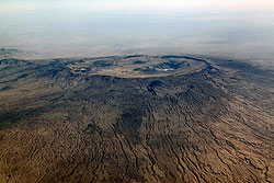


A2 Kroepelin Fig 1 lhk 250px
Emi Koussi (3,445 m) and its craters in the Tibesti mountains of northern Chad.
Photo: Stefan Kröpelin
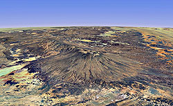
  A2 Kroepelin Fig 2 lhk 250pxSatellite view of Emi Koussi volcano and the southeastern Tibesti.
Source: Worldwind 3D


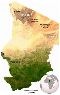
A2 Kroepelin Fig 3 lhk 250pxMap of Chad showing the expedition's main destinations.

Project


Project

Project A2
completed in 2017
(1st Phase) + (2nd Phase)


Principal Investigator:

Dr. Stefan Kröpelin
Prof. Dr. Bülent Tezkan
Prof. Dr. Martin Melles


Researcher:

Pritam Yogeshwar


PhD Candidate:

Jan Kuper
Marc Seidel

Raising the Sahara’s most complete climate record

Raising the Sahara’s most complete climate record

Coring the complete set of deposits at the bottom of a desert lake in northeast Chad in one of the driest and most isolated parts...

Exploring the subsurface – Geophysics in the Azraq...

Exploring the subsurface – Geophysics in the Azraq Basin, Northern Jordan

Non-invasive surface geophysical techniques are a useful tool to investigate the earth’s subsurface structure. In order to identif...

Advances in laboratory analyses of the Lake Yoa lo...

Advances in laboratory analyses of the Lake Yoa long core

While planned field work in Wadi Shati in Libya was impossible for obvious reasons, progress has been made on laboratory analyses...

Resolving sedimentary deposits in the Azraq Basin/...

Resolving sedimentary deposits in the Azraq Basin/Jordan using non-invasive geophysical techniques

A second geophysical field survey was undertaken in the Azraq Basin in October 2012.  

The lakes of Ounianga – Chad's first UNESCO World...

The lakes of Ounianga – Chad's first UNESCO World Heritage site

The 19 lakes of Ounianga in the hyperarid desert of northeastern Chad are the Sahara's most important relic from her early- to mid...

Into the Sahara Desert’s Deep Past. Expedition to...

Into the Sahara Desert’s Deep Past. Expedition to the Remote Tibesti Mountains

It is hard to believe: We have sent a probe 500 million km to a comet to analyze rock samples, but no geologist has yet dug his sp...

Applied Geophysics at Lake Chew Bahir, Southern Et...

Applied Geophysics at Lake Chew Bahir, Southern Ethiopia

In November/December 2014, four scientists from the Institute of Geophysics and Meteorology of the University of Cologne conducted...

Exploring sedimentary basins in the East-African R...

Exploring sedimentary basins in the East-African Rift Valley System

Three month after the first journey to Southern Ethiopia, a group of scientists from the Institute of Geophysics and Meteorology o...

Ennedi mission

Ennedi mission

In October 2015, A2 members followed an invitation for a field trip in the Ennedi massif of NE Chad. Main purpose was the evaluati...

The paradox of the Tibesti crater palaeolakes (Sah...

The paradox of the Tibesti crater palaeolakes (Sahara, Northwest Chad)

Recent field work in the Tibesti Mountains opens a new chapter in the reconstruction of the last climatic cycles in the central Sa...

Exhibition “Tibesti - Expedition in the Sahara” at...

Exhibition “Tibesti - Expedition in the Sahara” at the Kanzlergalerie

After the well-attended exhibitions on project A2’s geoarchaeological research and related World Heritage endeavours in Northern C...

Back from another mission in the Tibesti (Central...

Back from another mission in the Tibesti (Central Sahara)

A2 members just returned from another equally demanding as rewarding four-week expedition in the Tibesti mountains. The team compr...

The Ennedi Massif: Natural and cultural landscape...

The Ennedi Massif: Natural and cultural landscape – Chad’s second World Heritage site

18 years after an initiative taken by Stefan Kröpelin in 1999, UNESCO’s World Heritage Committee has unanimously inscribed the Enn...

logo qsga small new

logo koeln schrift 120x120 transparent

     logo uni bonn 153x40      dfg logo transparent
 

RWTH Aachen University

  logo geoverbund small 2 

logo koeln schrift 120x120 transparent

  logo Twitter
Copyright © 2021 CRC 806 - Our Way to Europe